


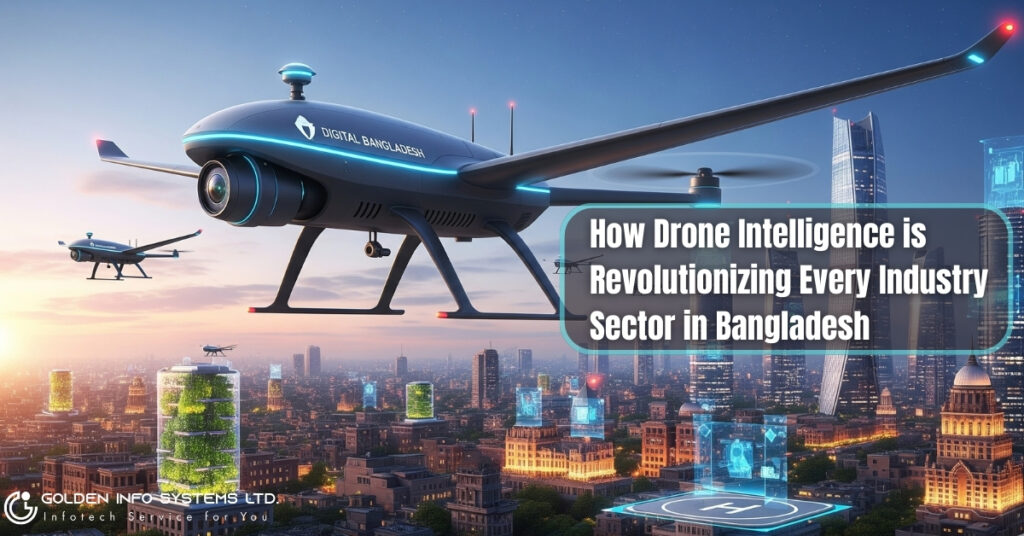
Explore the drone revolution in Bangladesh. See how intelligent drones are transforming agriculture, disaster management, and infrastructure for unprecedented growth
Dhaka, Bangladesh – A technological revolution is quietly unfolding in the skies above Bangladesh. Unmanned aerial vehicles (UAVs), more commonly known as drones, are rapidly evolving from niche gadgets to indispensable tools, reshaping industries and driving unprecedented efficiency and innovation. Equipped with advanced artificial intelligence (AI), high-resolution sensors, and sophisticated data processing capabilities, drone intelligence is proving to be a game-changer across a multitude of sectors in the nation, from the sprawling paddy fields of the countryside to the bustling urban landscapes.
This in-depth analysis explores the transformative impact of drone intelligence on key industries in Bangladesh, delving into specific use cases, the tangible economic and social benefits, the prevailing challenges, and the promising future of this disruptive technology.
Agriculture: A Green Revolution Fueled by Aerial Insights
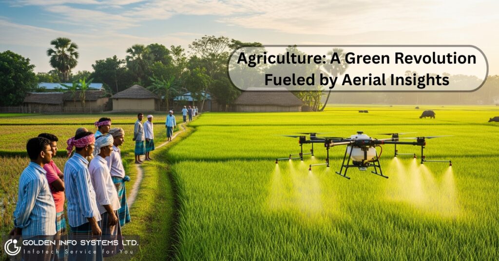
Agriculture, the lifeblood of Bangladesh’s economy, is at the forefront of the drone revolution. For a nation constantly striving for food security amidst a growing population and the escalating threats of climate change, precision agriculture powered by drone intelligence is a beacon of hope.
Precision Farming and Crop Monitoring: Drones equipped with multispectral and hyperspectral sensors are providing farmers with an eagle-eye view of their fields, offering invaluable data on crop health, soil conditions, and hydration levels. This allows for the precise application of fertilizers, pesticides, and water, a practice known as precision agriculture. The result is a significant reduction in input costs, minimized environmental impact, and a substantial boost in crop yields. The government of Bangladesh, in partnership with organizations like the Asian Development Bank (ADB), has initiated projects to train agricultural extension officers in using drone and satellite imagery for routine field assessments, signaling a strong commitment to modernizing the sector.
Pest and Disease Detection: Early detection of pest infestations and crop diseases is critical to preventing widespread damage. AI-powered drones can analyze crop imagery to identify subtle changes in plant health that are invisible to the human eye, enabling timely and targeted interventions. This proactive approach not only saves crops but also reduces the reliance on broad-spectrum pesticides, leading to safer and more sustainable farming practices.
Efficient Spraying and Seeding: Agricultural drones are now being deployed for the automated spraying of pesticides and fertilizers and even for sowing seeds. These drones can cover large areas in a fraction of the time it would take for manual labor, ensuring a uniform application and reducing the health risks to farmworkers associated with chemical exposure.
The economic implications are profound. With the potential to increase yields by up to 20% and significantly cut down on input costs, drone technology is empowering Bangladeshi farmers to enhance their profitability and contribute more effectively to the nation’s food security.
Disaster Management: A Lifeline from the Skies
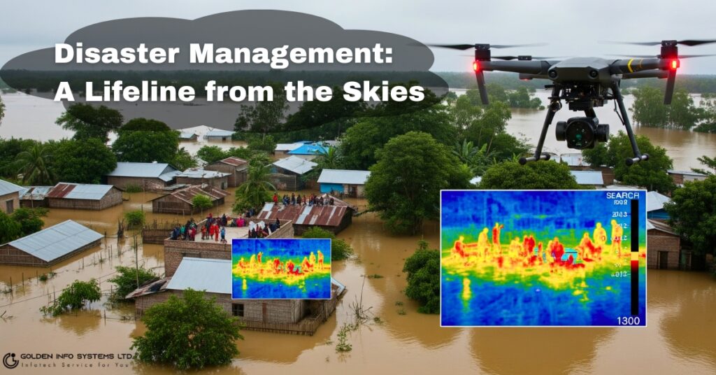
Bangladesh’s geographical location makes it one of the most disaster-prone countries in the world. From devastating floods and cyclones to landslides, the nation is in a constant battle against the forces of nature. In this challenging landscape, drones have emerged as a powerful ally in disaster management and emergency response.
Rapid Damage Assessment: In the immediate aftermath of a natural disaster, obtaining a clear and accurate assessment of the damage is paramount for effective relief and recovery efforts. Drones can be swiftly deployed to survey inaccessible and hazardous areas, providing high-resolution imagery and 3D maps of the affected regions. This real-time data allows disaster management agencies to understand the scale of the devastation, identify critical infrastructure damage, and prioritize the allocation of resources.
Search and Rescue Operations: In the chaotic aftermath of a disaster, locating and rescuing survivors is a race against time. Drones equipped with thermal imaging cameras can detect body heat, making them invaluable tools for finding individuals trapped under debris or in remote locations. Their agility allows them to navigate through confined spaces and treacherous terrains that are inaccessible to human rescue teams.
Delivery of Emergency Supplies: For communities isolated by floods or landslides, drones can be a lifeline, delivering essential supplies such as food, water, and medical kits. Startups like Rroketo are developing autonomous drone delivery systems with the capability to carry significant payloads over long distances, promising to revolutionize last-mile delivery in disaster-stricken areas.
The World Bank has actively supported the use of drone and GIS mapping tools in Bangladesh for designing disaster-resilient shelters, showcasing the international recognition of this technology’s potential in building a more resilient nation.
Infrastructure and Urban Planning: Building a Smarter Bangladesh
Bangladesh is in the midst of a massive infrastructure development boom, with mega-projects like the Padma Bridge and the Dhaka Metro Rail transforming the nation’s landscape. Drone intelligence is playing a pivotal role in ensuring the efficiency, safety, and quality of these ambitious undertakings.
Land Surveying and Mapping: Traditional land surveying is a time-consuming and labor-intensive process. Drones equipped with LiDAR (Light Detection and Ranging) technology can create highly accurate 3D topographic maps of vast areas in a fraction of the time. This data is crucial for the initial planning and design phases of infrastructure projects, enabling engineers to make informed decisions and optimize project layouts.
Construction Monitoring and Progress Tracking: Drones are being used to monitor construction sites, providing project managers with a comprehensive overview of the progress. Regular aerial surveys can track the deployment of resources, identify potential bottlenecks, and ensure that the project is adhering to the planned timeline and design specifications. This level of oversight enhances transparency and accountability in large-scale construction projects.
Infrastructure Inspection and Maintenance: The inspection of critical infrastructure such as bridges, power lines, and telecommunication towers is often a hazardous and expensive task. Drones can safely and efficiently conduct detailed visual and thermal inspections of these structures, identifying structural weaknesses, corrosion, and other potential issues before they escalate into major problems. This proactive approach to maintenance not only enhances safety but also extends the lifespan of critical national assets.
The Ready-Made Garment (RMG) Sector: A Glimpse into the Future of Smart Factories
While the adoption of drone technology in Bangladesh’s powerhouse Ready-Made Garment (RMG) sector is still in its nascent stages, the potential for transformation is immense. The industry is already embracing AI and the Internet of Things (IoT) for quality control and supply chain management, and drones are poised to be the next frontier in creating smarter, more efficient factories.
Potential for Automated Inventory Management: In the vast warehouses of RMG factories, manually tracking inventory is a daunting task. Drones equipped with RFID scanners could potentially automate this process, flying through the storage facilities and conducting rapid and accurate stock counts. This would provide real-time inventory data, reducing discrepancies and improving overall supply chain efficiency.
Enhanced Security and Surveillance: Drones can provide an additional layer of security for large factory complexes, monitoring perimeters and detecting unauthorized access. They can also be used for internal surveillance to ensure compliance with safety protocols and identify potential hazards in the workplace.
While the widespread implementation of drones in the RMG sector is yet to be seen, the industry’s continuous drive for innovation and efficiency suggests that it is only a matter of time before these aerial workhorses become a common sight in the skies above Bangladesh’s garment factories.
Energy Sector: Powering the Nation with Precision
The energy sector in Bangladesh is increasingly turning to drone intelligence to enhance the efficiency, safety, and reliability of its power generation and distribution infrastructure.
Power Line and Substation Inspection: Drones are proving to be invaluable for the inspection of vast networks of power lines and electrical substations. Equipped with high-resolution and thermal cameras, they can identify overheating components, damaged insulators, and vegetation encroachment, all of which can lead to power outages. This allows for proactive maintenance, preventing costly downtime and ensuring a stable supply of electricity.
Renewable Energy Asset Management: With the growing focus on renewable energy, drones are being used for the inspection and maintenance of solar farms and wind turbines. They can quickly and safely identify defective solar panels and damaged turbine blades, ensuring that these green energy assets are operating at optimal efficiency. A notable case study is NRECA International’s use of drones to map the territory of an electric utility in Bangladesh, helping to improve service and efficiency.
Logistics and E-commerce: The Dawn of Drone Delivery
The bustling e-commerce landscape and the increasing demand for faster and more efficient delivery services are paving the way for the adoption of drone-based logistics in Bangladesh.
Last-Mile Delivery Solutions: The final leg of the delivery journey, often referred to as the “last mile,” is typically the most expensive and inefficient part of the logistics chain. Drones offer a promising solution to this challenge, with the potential to bypass traffic congestion and deliver packages directly to customers’ doorsteps. As mentioned earlier, Bangladeshi startups are already making strides in this area, developing long-range delivery drones.
Medical and Emergency Deliveries: The ability of drones to quickly transport small, high-value payloads makes them ideal for the delivery of medical supplies, such as blood bags, vaccines, and essential medicines, particularly to remote and inaccessible areas. This has the potential to save lives and significantly improve healthcare outcomes in rural communities.
Media and Entertainment: A New Perspective on Storytelling
The media and entertainment industry in Bangladesh has embraced drone technology to capture breathtaking aerial footage and bring a new level of dynamism to filmmaking, journalism, and event coverage.
Cinematic Storytelling: Drones have democratized aerial cinematography, allowing filmmakers to capture stunning shots that were previously only possible with expensive helicopters. This has opened up new creative possibilities for Bangladeshi directors and cinematographers, enabling them to tell stories with greater visual impact.
News Gathering and Live Broadcasting: In the fast-paced world of journalism, drones provide a unique and often safer way to cover breaking news stories and large-scale events. They can provide live aerial feeds, offering audiences a comprehensive and immersive viewing experience.
The Road Ahead: Challenges and the Promising Future
Despite the immense potential of drone intelligence, its widespread adoption in Bangladesh is not without its challenges. These include:
- Regulatory Framework: The development of a clear and comprehensive regulatory framework for drone operations is crucial for ensuring safety, security, and privacy. The Civil Aviation Authority of Bangladesh (CAAB) has established guidelines, but these are continuously evolving to keep pace with technological advancements.
- Cost and Accessibility: The initial investment in high-end drone technology and the associated software and training can be a barrier for small and medium-sized enterprises.
- Lack of Skilled Personnel: There is a growing demand for skilled drone pilots and data analysts who can effectively operate the technology and interpret the vast amounts of data it generates.
- Public Perception and Acceptance: Building public trust and addressing concerns about privacy and security are essential for the long-term acceptance of drone technology.
Despite these hurdles, the future of drone intelligence in Bangladesh looks incredibly bright. The government is actively promoting the adoption of this technology, and a burgeoning ecosystem of startups and innovators is emerging. Organizations like Bangladesh Flying Labs are playing a crucial role in fostering local talent and developing drone-based solutions for local challenges.
The continued advancements in AI, sensor technology, and battery life will only expand the capabilities and applications of drones in the years to come. From monitoring the health of the Sundarbans to enhancing urban security, the possibilities are virtually limitless. As Bangladesh continues on its path of rapid economic development, drone intelligence will undoubtedly be a key enabler of progress, efficiency, and innovation across every sector of its vibrant economy. The sky, it seems, is no longer the limit; it’s the new frontier of opportunity.
Frequently Asked Questions (FAQ)
1. What are the main benefits of using drone intelligence in Bangladesh?
The primary benefits are increased efficiency, enhanced safety, significant cost reduction, and access to highly accurate data. For example, in agriculture, drones lead to higher crop yields and lower use of pesticides. In disaster management, they enable rapid damage assessment and aid in search and rescue missions, saving lives. For infrastructure, they make inspections of bridges and power lines safer and more efficient.
2. Is it legal to fly a drone in Bangladesh?
Yes, but it is regulated. The Civil Aviation Authority of Bangladesh (CAAB) has specific rules and guidelines for drone operation. There are different categories based on the drone’s weight and purpose (recreational vs. commercial). Generally, you need to register your drone with CAAB and may require a permit or “No Objection Certificate” (NOC) for flying in certain areas, especially for commercial purposes. It is crucial to always check the latest CAAB regulations before flying.
3. Which industry in Bangladesh is benefiting the most from drones right now?
Currently, the Agriculture and Disaster Management sectors are seeing the most significant and widespread benefits. The ability of drones to provide precise data for farming and conduct rapid surveys in disaster-stricken areas addresses two of the nation’s most critical challenges: food security and climate resilience. The infrastructure and media sectors are also rapidly adopting the technology.
4. What are the biggest challenges to widespread drone adoption in Bangladesh?
The main challenges include:
- A complex regulatory environment that can be difficult to navigate for new users.
- The high initial cost of professional-grade drones and associated software.
- A shortage of skilled pilots and data analysts who can operate the technology and interpret the data effectively.
- Public perception issues related to privacy and security concerns.
5. How can a business in Bangladesh get started with using drones?
To integrate drones into your business, you should:
- Research: Thoroughly understand the current CAAB regulations for commercial drone use.
- Define Your Goal: Clearly identify what business problem you want to solve with drones (e.g., crop monitoring, site surveying, asset inspection).
- Select the Right Technology: Choose a drone and sensor package that fits your specific needs and budget.
- Invest in Training: Ensure you have certified pilots and trained personnel to manage and analyze the data.
- Start Small: Begin with a pilot project to demonstrate the return on investment (ROI) before scaling up your operations.
6. What is the future of drone technology in Bangladesh?
The future is incredibly promising and revolves around integration with other advanced technologies. As cloud infrastructure continues to expand in 2025 and beyond, it will become easier to process the massive datasets collected by drones in real-time. We will see greater autonomy through Artificial Intelligence (AI), allowing drones to perform complex tasks with minimal human intervention. Expect to see drone fleets integrated with IoT (Internet of Things) networks for creating “smart cities” and more resilient supply chains, pushing the boundaries of what is possible across all industries.